Off-the-Beaten-Path Peru Itinerary
Half the "undiscovered Peru" lists still recommend Rainbow Mountain, which now sees thousands of people a day. Here is what is genuinely quiet, what only used to be, and a 14-day northern circuit with the real travel times attached.
Search off the beaten path peru and count how many of the first ten results send you to Rainbow Mountain. I did it again this month and got six. Six pages recommending a ridge that Cusco’s regional tourism office has forecast at more than 1,500 visitors a day in high season, and that guides on the ground put closer to 3,000 on a Saturday in July. The same lists push Humantay Lake, where every van leaves Cusco between 4am and 5am and tips its passengers onto the same 200 metres of shoreline within the same forty minutes.
That is the state of this category. It is written by people who have not been, or by agencies that need to fill a day tour, and the result is a genre where “undiscovered” means “discovered in 2015 and now has a ticket office, a car park and a queue for the photo spot”.
So this guide does three things differently. It grades the usual suspects honestly, including the ones I think you should skip. It sorts real alternatives into three tiers — genuinely remote, quiet but accessible, and formerly quiet and now not. And it gives you a day-by-day 14-day route through the north, because the north is where quiet Peru actually still is. I have also written the part almost nobody writes: what you give up when you leave the standard Lima–Cusco–Machu Picchu circuit, in hours, soles and risk.
Off the beaten path Peru: how I grade the claims
“Off the beaten path” is not a vibe. It is a measurable thing, and I grade it on four questions:
- How many people are there on a normal day in high season? Not on the operator’s best-case Tuesday in February. On a Saturday in July.
- Can you get there on a day trip from a tourist hub? Anything within four hours of Cusco by road will be busy within a decade of appearing on Instagram. Physics of tourism.
- Is there paved road access, or scheduled flights? Infrastructure is destiny. The moment a road is sealed, the visitor count doubles.
- Do you need Spanish, time, or a tent to get there? Each of those three filters out most of the market. Two of them filter out almost all of it.
By those tests, a lot of what gets sold as remote Peru is simply the second-tier standard circuit. And a few genuinely empty places sit two hours from a paved highway with nobody on them, because they lack a photogenic hook.
The grading table: what the lists recommend versus what you will actually find
| Place | Usually sold as | Crowd reality in 2026 | Does it deserve the label? |
|---|---|---|---|
| Vinicunca (Rainbow Mountain) | Hidden Andean secret | Roughly 1,000–1,500 people daily in season, reports of 3,000 on peak July and August days; queues at the 5,036 m summit ridge | No. It is Peru’s second-busiest attraction |
| Humantay Lake | Quiet alternative to Rainbow Mountain | Third-busiest site in the Cusco region; every tour arrives inside the same hour because of the shared 4am departure | No |
| Palccoyo | The uncrowded Rainbow Mountain | Quieter than Vinicunca and an easier walk, but it now has its own dedicated day-tour market out of Cusco | Not any more. It was true in 2018 |
| Pallay Punchu | The new secret rainbow ridge | The current recipient of the overflow. Busy weekends, still calm midweek | Borderline, and heading the same way |
| Ausangate circuit | Crowd-free Andean trek | The full circuit is genuinely quiet; the Vinicunca-adjacent sections and the “7 lakes” day trip are not | Yes for the circuit, no for the day tour |
| Huacachina | Desert oasis few people know | A backpacker resort with buggy tours running on a timetable | No, and it has not been for twenty years |
| Nazca and Paracas | Off the tourist trail | Both sit on the main Lima–Cusco bus corridor with hop-on tourist buses stopping daily | No |
| Colca Canyon | Wild condor country | Cruz del Condor viewpoint has coach parking and a fixed morning rush | No, though the far end near Cabanaconde thins out fast |
| Taquile, Lake Titicaca | Untouched island life | Included on standard two-day Puno boat tours | No. Amantani overnight stays are quieter |
| Chan Chan and Trujillo | Overlooked north coast | Steady but light foreign traffic; you can have Huaca de la Luna nearly to yourself midweek | Yes, relative to Cusco |
| Kuelap | Machu Picchu of the north | Mostly Peruvian visitors, busiest at weekends and on national holidays. I have met travellers who saw no other foreigner all day | Yes, with an asterisk on the comparison |
| Gocta Falls | Recently discovered waterfall | A steady trickle of independent hikers and small groups; never a queue | Yes |
| Laguna 69 | Hidden glacial lake | The single busiest day hike in the Cordillera Blanca. Dozens of minibuses at the trailhead in July | No, but the crowd disperses over 13 km |
| Santa Cruz trek | Peru’s quiet four-day trek | The best-known trek out of Huaraz. Busy campsites in August, empty in May | Partly. Season-dependent |
| Cordillera Huayhuash circuit | Expedition trekking | Dozens of people on the whole circuit at once, not per campsite | Yes, emphatically |
| Choquequirao | The other lost city | Commonly reported at under 50 visitors a day, and there are days with fewer than a dozen | Yes, the strongest case in Peru |
| Caral | Oldest city in the Americas | A UNESCO site three hours from Lima that many days sees a handful of visitors | Yes, and it is bizarre that it is quiet |
| Kuntur Wasi and the Cajamarca sites | Serious pre-Inca archaeology | Almost entirely domestic visitors and school groups | Yes |
| Cotahuasi Canyon | World’s deepest canyon | A 10–12 hour road trip from Arequipa keeps numbers tiny | Yes |
| Pacaya-Samiria, out of Iquitos | Deep Amazon | Multi-day boat access only; a fraction of the traffic that Tambopata sees | Yes |
| Marcahuasi | Mysterious stone forest | Very few foreigners; a weekend camping spot for Limeños | Yes, with caveats about the four-hour climb |
| Q’eswachaka rope bridge | Secret Inca bridge | Quiet most of the year; the June rebuilding festival is heavily attended | Yes outside June |
If you take one thing from that table: the crowd problem in Peru is geographically concentrated. It is Cusco, Machu Picchu, and a ring of day trips around them, plus a strip of the southern coast. Step outside that box in any direction and the numbers collapse. Which is why the honest version of this article is less a list of secret places and more a route map for the two-thirds of the country the standard Peru itinerary skips entirely.
Tier 1: genuinely remote
These places cost you days, not hours. Every one of them requires either a multi-day walk, a long road journey on partly unpaved surfaces, or both. In exchange, you get something that is now very hard to buy in Peru: solitude at a world-class site.
Choquequirao, and the cable car that keeps not being built
Choquequirao is the strongest answer to the whole question. It is an Inca complex on a spur above the Apurimac at around 3,050 m, with terracing, plazas and a set of llama figures worked into a retaining wall in white stone. Excavation has covered only a fraction of it. And the only way in is on your own feet.
The standard trip is four days out of Cachora, roughly four hours by road from Cusco. Day one drops you about 1,500 m to the Apurimac; day two climbs the same amount back up the other side; day three is the site; day four is the whole thing in reverse. That descent-then-ascent structure is the part people underestimate. It is not high-altitude suffering in the Salkantay sense — it is heat, dust and relentless gradient, and the climb out of the canyon on the last day is genuinely hard in the afternoon sun. Guided four-day trips run roughly US$400–700 per person with mules, a cook and camping gear, and the site entrance is around S/60.
I checked the cable car situation again while writing this, because it matters and because it has been announced so often that half the internet believes it exists. As of now, there is no cable car to Choquequirao and no construction underway. The project — a roughly 10 km line from Huanipaca on the Apurimac, budgeted at around US$261 million under a public-private partnership run through ProInversion — has been through repeated award timetables since the 2010s. It is still live on paper, and the government keeps saying an award is coming in the next quarter. Do not plan a trip around it. If it is ever built it will convert Choquequirao from a four-day trek into a twenty-minute ride, and this article will need rewriting.
Realistically, the window in which you can walk into a major Inca site and share it with a dozen people is finite. If that appeals more than the crowd-managed experience at Machu Picchu, go now rather than in five years.
The Cordillera Huayhuash
If Choquequirao is the archaeology answer, the Huayhuash is the mountain answer. It is a compact range south of Huaraz, and the full circuit takes 8–12 days over a string of passes mostly between 4,600 m and 5,000 m, with camps beside lakes that look artificially coloured. Siula Grande, the peak from Touching the Void, is on it.
Two things make it genuinely remote rather than merely hard. First, you are days from a road for most of it. Second, you pay community fees in cash at a series of checkpoints run by the villages the route crosses — budget a few hundred soles in small notes across the circuit, and expect the amounts to change without notice. There is no ATM, no shop, no phone signal for long stretches, and no realistic prospect of a quick evacuation from the far side of a 4,800 m pass.
Compared with the marquee routes on any list of the best treks in Peru, the Huayhuash is a different order of commitment. Go with a guided group and pack animals unless you have serious high-altitude experience and a partner who does too.

Cotahuasi, and the canyons nobody drives to
Cotahuasi is deeper than Colca and gets a tiny fraction of the visitors, for one reason: the road. It is a 10–12 hour trip from Arequipa, much of it slow, and there is no tour bus circuit feeding it. What you get is a canyon floor with villages, terraces, hot springs and the Sipia falls, and days where you will not see another foreign traveller.
This is the clearest example of the infrastructure rule. Cotahuasi is not hidden. It is on maps, it has hostels, it has a bus from Arequipa. It is empty because getting there costs you two days of your holiday, and most people will not spend two days on a canyon.
Iquitos and the deep Amazon
Peru has two Amazon gateways and they are not equivalent. Puerto Maldonado is an hour’s flight from Cusco, with lodges a short boat ride up the Tambopata and Madre de Dios, and it is where the vast majority of visitors doing a three-night jungle add-on end up. It is good — macaw clay licks, giant otters, night walks — but it is the packaged version.
Iquitos is the largest city in the world with no road connection to anywhere. You fly in, or you take a multi-day riverboat. From there, the serious option is a live-aboard trip into the Pacaya-Samiria reserve, which is a matter of days upriver rather than an hour’s transfer, and where you are looking at pink river dolphins, flooded forest and a genuinely low density of other tourists. It costs more and eats more days than a Tambopata lodge, and it is the version worth doing if the Peruvian Amazon is a main reason for your trip rather than a bolt-on.
One honest caveat: high water (roughly December to May) and low water (June to November) give you completely different trips. High water means you travel by canoe through the canopy; low water means beaches, better land walking and easier mammal spotting. Neither is wrong, but nobody selling you a lodge will volunteer the difference. If your priority is Peru’s wildlife rather than the river itself, ask specifically which season your dates fall in.
Tier 2: quiet but you can actually get there
This is the tier most travellers should care about. These places have hotels, restaurants, road access and, in a couple of cases, an airport — and they are still nothing like Cusco in July.
Chachapoyas and Kuelap
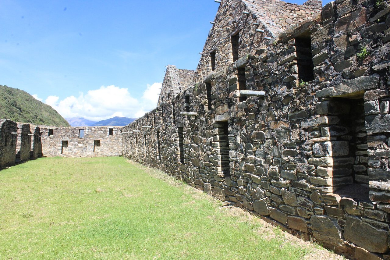
Chachapoyas is a small, pleasant colonial town at 2,335 m in the Amazonas region, and it is the base for the best cluster of sites in northern Peru. Kuelap is the headline: a walled Chachapoya settlement at about 3,000 m, with outer walls reaching 20 m in places and something like 400 circular stone houses inside, most of it built between roughly AD 900 and 1100 — centuries before the Inca arrived in the 1470s.
The access situation, verified rather than assumed. Part of the southern perimeter wall collapsed in April 2022 after prolonged rain. The site closed for most of 2023, reopened in phases through 2024, and the major restoration campaign has since finished, with more of the interior open than before the collapse. As of 2026 entry and exit are through the Service Entrance while conservation work continues in other sectors. Tickets are online only through the Ministry of Culture portal, currently S/30 for foreign adults and S/20 for Peruvians and Andean Community nationals, with timed entry slots from 9am and the site closed on Mondays.
The cable car is running — the Telecabinas Kuelap system from Nuevo Tingo, open since 2017, which climbs about 660 m over 4 km in a 20-minute ride and costs around S/26.5 return, cash preferred. Two things to know. It shuts for several weeks of scheduled maintenance most years, usually in May; in 2026 that window was 4–25 May. And it suspends at short notice for heavy rain, high wind, lightning and rockfall on the line, which is a real risk in the wet season. The site normally stays open when the cable car is down, but you are then looking at the long unsealed road instead. Check the operator’s calendar before you commit a day to it.
Is Kuelap the “Machu Picchu of the north”? No, and I would rather you knew that in advance. The scale is impressive on paper and less so standing in it, because most structures survive as low circular walls, drones are banned and there is no viewpoint that gives you the aerial shot the marketing uses. Those thatched conical roofs in the promotional photos were removed. Go for what it is — the most important Chachapoya site, in a landscape where the Andes hit the cloud forest — and it is excellent. Go expecting a rival to the sites in any roundup of Inca ruins in Peru and you will be flat.
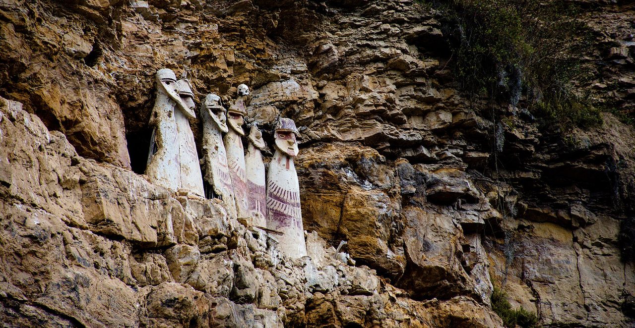
The rest of the cluster is what makes the trip worth it: the Karajia sarcophagi, painted clay figures standing on a cliff ledge and visible from the path below; the Revash mausoleums, little red-and-white tomb houses set into a rock face; the Leymebamba museum, which holds hundreds of mummies recovered from the Laguna de los Condores; and Quiocta cave. Individually none of them is a full day. Together they are four.
Gocta Falls
Gocta is a two-tier waterfall of 771 m, an hour or so from Chachapoyas, and it was only measured and publicised internationally in 2006. The standard walk from Cocachimba is about 10–11 km round trip and takes most people five to six hours, with an entrance fee around S/10–15 paid in cash at the village. Horses can be hired for the first climb, which is the steepest part.
Best months are a genuine trade-off. April to June gives you strong flow with the rain mostly finished. July to September gives you reliable skies and a thinner fall. In the wet the trail turns to clay and the whole thing becomes an exercise in staying upright. The falls are not crowded in any season — on a weekday you may pass a dozen people over six hours.
Huaraz and the Cordillera Blanca
Huaraz sits at about 3,050 m and is 7–9 hours from Lima by bus, with fares typically running US$15–45 depending on the operator and seat class. That single road connection is why the Cordillera Blanca is the most accessible serious mountain range in South America and also why parts of it are no longer quiet.
Laguna 69 is the case in point. It sits at 4,600 m in Huascaran National Park, the hike is roughly 14 km return with about 840 m of climbing, the park fee is S/30 and organised day trips go for around US$20–25. In July and August the trailhead car park has dozens of minibuses in it. It is still a superb day and the crowd spreads out over the distance, but calling it undiscovered is nonsense.
The Santa Cruz trek, four days over the 4,750 m Punta Union pass, is the classic multi-day route and costs somewhere between US$165 and US$360 depending on how much support you buy, plus around S/65 in park fees paid in cash. Campsites are busy in August and near-empty in May. If you want the Blanca without the traffic, ask agencies about the Akilpo-Ishinca crossing, the Quilcayhuanca-Cojup loop, or simply do Santa Cruz in the shoulder weeks.
Huaraz has one non-negotiable rule: acclimatise. Coming straight from Lima at sea level to a 4,600 m day hike is how people end up on oxygen. Give it two nights and an easy warm-up walk — Laguna Wilcacocha or Laguna Churup — before anything big. The same logic applies anywhere high in Peru, and if you have already read up on managing altitude in Cusco, apply exactly the same discipline here, with less medical infrastructure to fall back on.
Caral, three hours from Lima and nearly empty
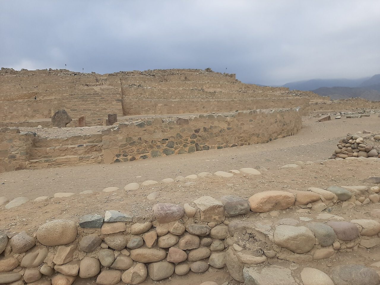
Caral is the oldest known urban centre in the Americas, occupied from around 2900 BCE, with six major platform mounds and sunken circular plazas spread over a desert terrace in the Supe valley about 180 km north of Lima. It is contemporary with the early Egyptian pyramids. It is a UNESCO World Heritage Site. It is roughly three to three and a half hours from the capital on the Panamericana.
And on a normal weekday you can walk it with a guide and a handful of other people. There is no monumental stonework to photograph in the Inca sense — this is adobe, cobble retaining walls and shaped desert — and that is exactly why it stays quiet. It rewards curiosity more than camera work. If your interest in Peru’s UNESCO sites goes beyond ticking off the famous ones, this is the one everyone misses, and it is embarrassingly easy to reach as a long day trip or an overnight from Lima.
Cajamarca, Kuntur Wasi and the northern highlands
Cajamarca, at 2,750 m, is where Atahualpa was captured and ransomed, and the Cuarto del Rescate is still there. Around it: Cumbemayo, a pre-Inca aqueduct carved through volcanic rock at 3,500 m; the Ventanillas de Otuzco funerary niches; and Kuntur Wasi, a hilltop ceremonial centre west of the city where Japanese archaeologists found the oldest worked gold yet identified in the Americas, roughly 2,800 years old, now displayed in a small site museum.
Foreign visitor numbers here are negligible. Signage is Spanish-only at most sites, guides are Spanish-speaking, and the whole region operates on domestic tourism rhythms. That is the deal: you trade convenience for a genuinely different northern Peru experience where you are not a demographic anyone is designing for.
Tier 3: used to be off the beaten path, and is not any more
I would rather be blunt about these than pad the list, because seeing them recommended as secrets is how you end up disappointed at 5am in a queue.
Rainbow Mountain (Vinicunca) went from unknown to Peru’s second-most-visited attraction in under a decade. The colours are real but far less saturated than edited photos, the summit ridge is at 5,036 m, and the trail carries horse traffic all the way up. If you still want it, the honest advice is in our full guide to visiting Rainbow Mountain: go on the earliest departure or, better, in the shoulder months.
Humantay Lake is genuinely beautiful and genuinely mobbed, for a structural reason — the tours all depart Cusco at the same hour and therefore all arrive at the same hour. Arriving after lunch, when the morning wave has gone, changes the experience completely. Our Humantay Lake guide covers the timing in detail.
Palccoyo was the correct answer to the Rainbow Mountain problem around 2018. It now has a dedicated day-tour market, a car park and a short paved-ish approach. It is still easier, lower and calmer than Vinicunca. It is no longer a secret, and the operators recommending it as one know that.
Huacachina, Nazca and Paracas sit on the main Lima–Cusco backpacker corridor with tourist buses stopping daily. They belong in an honest southern coast plan, not in a list of places nobody goes.
Lares and the Inca Jungle are marketed as the quiet alternatives to the Inca Trail. Compared with the classic four-day trail they are quieter. Compared with the Huayhuash they are a motorway. And all of them still funnel into Aguas Calientes and the same timed-entry system.
One thing worth understanding about why Cusco feels the way it does: Machu Picchu now runs on a daily cap of 4,500 visitors, rising to 5,600 on designated peak dates, split across three circuits and ten one-way routes that rangers actually enforce. Entry is S/163 for foreign adults, or S/211 for the circuits including Huayna Picchu or Machu Picchu Mountain, following the conservation surcharge added on 1 May 2026. Those caps have not reduced the crowd — they have redistributed it into the surrounding valley, which is part of why every day trip out of Cusco now has a rush hour. Check current prices and availability on the official portal and in our Machu Picchu ticket guide before you build a plan around it.
The 14-day northern circuit, day by day
This is the route I would actually give someone who says they want Peru without the crowds and has two weeks. It is Lima, the Amazonas cloud forest, the northern highlands, the north coast and the Cordillera Blanca. It contains no Machu Picchu and no Cusco, which is the point and also the catch.
It involves two internal flights and about 45–50 hours of ground transport across the fortnight. Read that number twice before committing.
| Day | Base | What you do | Moving time | Note |
|---|---|---|---|---|
| 1 | Lima | Arrive, Miraflores and Barranco, Larco museum in the afternoon | – | Do not schedule anything demanding on arrival day |
| 2 | Lima | Day trip north to Caral in the Supe valley | 6–7 hrs return | Leave by 6am; guided visit only, no independent wandering |
| 3 | Chachapoyas | Fly Lima–Jaen, then road to Chachapoyas | 1h45 flight + 3–4 hrs road | Jaen is the reliable route; direct Lima–Chachapoyas flights are small-aircraft and weather-sensitive |
| 4 | Chachapoyas | Karajia sarcophagi and Quiocta cave; Sonche canyon viewpoint late | 4–5 hrs driving | Easy first day at 2,335 m while you adjust |
| 5 | Chachapoyas | Kuelap: colectivo to Nuevo Tingo, cable car, site circuit | 7–8 hrs door to door | Book the timed entry online in advance; closed Mondays |
| 6 | Cocachimba | Gocta Falls hike, night at the falls village | 5–6 hrs walking | Cash for the entrance; horses available for the first climb |
| 7 | Leymebamba | Revash mausoleums and the Leymebamba museum | 5–6 hrs driving | The museum is the best-curated thing in the region |
| 8 | Cajamarca | The Balsas road: Leymebamba to Celendin to Cajamarca | 10–12 hrs | The hardest day of the trip. Alternative: back to Jaen and fly |
| 9 | Cajamarca | Cuarto del Rescate, Cumbemayo, Kuntur Wasi or Ventanillas de Otuzco | 4–6 hrs driving | Spanish-only guiding at most sites |
| 10 | Trujillo | Road down to the coast | 6–7 hrs | Big altitude drop; you will sleep well |
| 11 | Trujillo | Chan Chan, Huaca de la Luna, Huanchaco for the evening | 3–4 hrs driving | Huaca de la Luna murals are the highlight, not Chan Chan |
| 12 | Huaraz | Coast road south then inland to the Callejon de Huaylas | 8–9 hrs | Overnight bus is an option; you will arrive at 3,050 m |
| 13 | Huaraz | Acclimatisation walk: Laguna Wilcacocha or Laguna Churup | 4–6 hrs | Non-optional if Laguna 69 is on the plan |
| 14 | Huaraz to Lima | Laguna 69 or Laguna Paron, then the night bus back | Hike 6–7 hrs + 8 hr bus | Fly home the following morning, not the same night |
Two honest variants. If ten days is your ceiling, cut Cajamarca and the coast: Lima, Chachapoyas cluster for five nights, then fly back and do Huaraz. If you have three weeks and cannot bear to skip the south entirely, run this circuit and then add a week for Cusco — our three weeks in Peru plan shows how the two halves fit, and the standard 14-day route is the version to compare against if you are still deciding.
The transport reality nobody puts in these articles
The single biggest difference between the standard circuit and the alternative one is that the standard circuit has been engineered for tourists and the alternative one has not. Here is what that means in hours and money.
| Leg | Options | Time | Rough cost | Reality check |
|---|---|---|---|---|
| Lima → Chachapoyas | Fly to Jaen then road; or direct small-aircraft flight; or bus via Chiclayo | 5–6 hrs via Jaen; 22–26 hrs by bus | US$70–180 flight; US$30–50 bus | The direct flight has limited frequency and cancels for weather |
| Chachapoyas → Cajamarca | Bus or shared car via Celendin | 10–12 hrs | US$15–30 | Sections unpaved, hairpins above the Maranon, unpleasant if you get motion sickness |
| Lima → Huaraz | Overnight or daytime bus | 7–9 hrs | US$15–45 | The most reliable long leg in this whole guide |
| Cusco → Cachora (Choquequirao trailhead) | Private transfer or bus and taxi | 4 hrs | Included in most trek packages | The road is fine; the trek is the hard part |
| Lima → Iquitos | Flight only, or multi-day riverboat from Yurimaguas or Pucallpa | 2 hrs flying; 3–5 days by boat | US$80–200 flight | No road exists. None is coming |
| Arequipa → Cotahuasi | Overnight bus | 10–12 hrs | US$15–25 | One or two departures a day; check the day before |
Beyond raw hours, three practical things change once you leave the tourist corridor. Card acceptance drops sharply — carry more cash and in smaller notes than you would in Cusco. Departure times are advisory rather than binding on smaller operators. And schedules are seasonal in a way nobody publishes; a route that runs twice daily in July may run three times a week in February. Our general guide to getting around Peru covers the bus companies worth paying extra for, and the advice holds double up north where the cheap operators are genuinely worse.
What you actually give up
Every article in this category sells the upside. Here is the other half.
Time. A day trip in Cusco costs you a day. A day trip in Amazonas costs you a day plus the two travel days that got you into the region. The north is not more expensive per day, it is more expensive per sight.
Spanish. In Cusco you can travel comfortably on English. In Chachapoyas, Cajamarca and Cotahuasi, English is genuinely rare outside a couple of hotels. Site guiding is in Spanish. Bus terminals are in Spanish. You can manage with a translation app and patience, but it is a real cost in friction and you should know that going in rather than discovering it at a counter in Celendin.
Infrastructure. Fewer hotels above the basic tier. Fewer restaurant options after 9pm. Patchier mobile data in the valleys. Fewer ATMs, and a real chance the one in town is out of cash on a Sunday. None of it is hardship; all of it is friction.
Altitude on top of remoteness. Huaraz is 3,050 m and its best day hikes are at 4,600 m. Cajamarca is 2,750 m. Kuelap is 3,000 m. The Huayhuash crosses passes near 5,000 m. Getting altitude sick in Cusco means a clinic within fifteen minutes and a flight to Lima if it is serious. Getting altitude sick in the Callejon de Huaylas or on a trek means a long descent by road at best.
Rescue. This is the one that gets glossed over. “No crowds” on a trekking route also means nobody will find you quickly. The Cordillera Blanca has a police high-mountain unit and Huaraz has an established guiding community, but there is no on-call helicopter service you can count on, and evacuation from a remote camp is measured in hours or days. If you are doing anything multi-day, buy travel insurance that explicitly covers trekking above 4,500 m — most standard policies do not — and carry a satellite messenger on the Huayhuash. Our broader Peru travel tips cover insurance and safety basics, but remote trekking needs a higher standard than city travel.
The wet season is not a minor inconvenience. On paved routes, rain is annoying. On the Balsas road, in the Huayhuash, or on the Choquequirao descent, rain means landslides, closed roads and cancelled cable cars. That is the difference between a wet-season trip on the standard circuit and a wet-season trip out here.
Seasonality: when this route works and when it does not
The rough shape of the year in the Peruvian highlands is a dry season from May to September and a wet season from November to March, with April and October as transitional months. That pattern drives everything on this itinerary.
- May to early June. My pick for the north. Rain has finished, the cloud forest is still green, Gocta is running strong, and the Cordillera Blanca trekking season is opening with quiet campsites. Watch for the Kuelap cable car maintenance window, which has typically fallen in May.
- July and August. The most reliable weather and the coldest nights. Also the only time the northern circuit gets anything like busy, and the peak for Huaraz trekking. Book the Huayhuash and Santa Cruz ahead.
- September and October. Excellent and underrated. Stable enough for trekking, thinner crowds, better light for photography as cloud starts returning to the Amazonas valleys.
- November to March. I would not run the 14-day route as written. The Balsas road becomes a gamble, Choquequirao is genuinely dangerous in heavy rain, the Huayhuash is out, and the cable car suspends for storms. The exception is the north coast, which is at its warmest and best from December to March, and the Amazon, which is simply a different trip at high water.
If your dates are fixed and they fall in the wet season, be honest with yourself and pick the coastal and Amazon version instead. There is more detail on regional variation in our guide to the best time to visit Peru, and the north does not follow the Cusco pattern as neatly as most articles imply.
What it costs
The alternative circuit is not a budget trip, despite what “fewer tourists” suggests. You spend less on entrance fees and more on transport. Rough per-person daily figures, mid-range, in a fortnight:
- Accommodation: S/90–200 a night for a decent double in Chachapoyas, Cajamarca or Huaraz. Cheaper than Cusco for the same standard.
- Food: S/15–30 for a menu del dia, S/40–80 for a proper dinner. The north is where Peruvian food gets regional and interesting — cuy in Cajamarca, juanes and cecina in the cloud forest towns.
- Transport: the big line item. Budget US$250–450 for the two flights plus all the ground legs in the 14-day route.
- Entrances: trivially cheap. Kuelap S/30, Gocta about S/10–15, Huascaran park fees S/30 for a day and S/65 for the Santa Cruz trek, Choquequirao around S/60.
- Guided treks: Santa Cruz US$165–360, Choquequirao US$400–700, Huayhuash considerably more again for 8–12 days with pack animals.
Overall I would budget similarly to a standard trip, with the money moved from tickets and trains into buses and flights. Our breakdown of what a Peru trip costs gives the comparison against the classic route.
Who should not do this
I would rather lose you here than have you unhappy in Celendin.
- First-time visitors to Peru. The classic circuit is famous because it is genuinely excellent. Do it first. Come back for the north.
- Anyone with under two weeks. Ten days is workable for a slice of it. Under ten and you will spend a third of the trip in transit. If that is your situation, our 10-day plan is a better use of the time.
- Anyone whose trip hinges on Machu Picchu. You cannot bolt the northern circuit onto a Cusco week. They are at opposite ends of the country. Pick one, or take three weeks.
- Travellers with no Spanish and low tolerance for improvising. Not impossible. Just harder than the brochures suggest.
- Anyone travelling November to March on unpaved routes. See above.
- Anyone who wants the greatest hits. There is nothing wrong with wanting Machu Picchu, the Sacred Valley and Lake Titicaca. If that is the trip you want, our list of the best places to visit in Peru will serve you better than this one.
Frequently asked questions
What is the most genuinely off-the-beaten-path place in Peru?
Of the places an ordinary traveller can realistically reach, Choquequirao. It is a major Inca site reachable only on foot, commonly reported at under 50 visitors a day, and the four-day round trip from Cachora filters out almost everyone. The Cordillera Huayhuash circuit is the equivalent answer for mountains, and Pacaya-Samiria for the Amazon.
Is Rainbow Mountain still off the beaten path?
No. It is Peru’s second-most-visited attraction after Machu Picchu, with high-season daily numbers commonly quoted in the 1,000–1,500 range and reports of around 3,000 on peak days. Any article listing it as a secret in 2026 has not checked.
Is the Kuelap cable car running?
Yes, at the time of writing. The Telecabinas Kuelap system operates year-round apart from a scheduled maintenance shutdown, which has recently fallen in May — in 2026 it ran from 4 to 25 May. It also suspends at short notice for storms, high wind and rockfall, mainly in the wet season. Check the operator’s current calendar before travelling. The archaeological site itself normally stays open when the cable car is down, but access then means the long unsealed road.
Is there a cable car to Choquequirao yet?
No. The project exists on paper — roughly a 10 km line from Huanipaca, budgeted near US$261 million as a public-private partnership — and award timetables have slipped repeatedly for more than a decade. Nothing is under construction. The only access is the trek.
Can you visit Peru without Machu Picchu and still have a good trip?
Yes, and the 14-day northern circuit above is proof of concept. You will miss the single most spectacular site in the country, and I would not pretend otherwise. Whether that trade works depends entirely on what you want from the trip; our honest take on whether Machu Picchu is worth it lays out both sides.
Do I need Spanish for northern Peru?
Close to mandatory in practice. Site guiding, bus terminals, colectivo drivers and most accommodation outside the main hotels operate in Spanish only. You can survive on a translation app and goodwill, but you will have a materially worse time than someone with even intermediate Spanish.
Iquitos or Puerto Maldonado for the Amazon?
Puerto Maldonado if you have three or four days and want macaw clay licks and giant otters with minimal transit — it is an hour from Cusco by air. Iquitos if the Amazon is a main reason for the trip and you can give it a week, because that is what a Pacaya-Samiria boat trip needs. Iquitos also gives you river culture and pink dolphins that Tambopata cannot.
How many days do I need for northern Peru?
Five nights in the Chachapoyas region covers Kuelap, Gocta, Karajia and Revash without rushing. Add four for Cajamarca, three for Trujillo and the coast, and four for Huaraz, and you are at the fortnight in the table above. Fewer than ten days and the travel time starts eating the trip; there is more on pacing in our guide to how many days you need in Peru.
Is Huaraz safe for solo travellers?
The town is straightforward and has a large trekking community, and solo travellers pass through constantly. The mountains are the risk, not the streets. Do not do remote high-altitude routes alone, register your plans with your accommodation or an agency, and buy insurance that covers trekking above 4,500 m.
Which single detour is worth adding to a standard Peru trip?
If you have three spare days in Cusco, Choquequirao is the one that changes the trip — though the four-day version needs four. If you only have one spare day, take a genuinely quiet option among the day trips from Cusco rather than the ones on every agency board, and go on a weekday. If you have a week, fly north.
Is the north better than the south?
No. It is quieter, cheaper per night, harder to travel and less spectacular at its peak. The south has Machu Picchu, Arequipa, Colca and Titicaca, and it has them because they are extraordinary. The north is what you do when you have already seen those, or when solitude matters to you more than the headline sights. The other way out of the southern circuit is to keep going south and cross the Titicaca border into Bolivia. Plenty of travellers find that the less obvious things to do in Peru end up being what they remember, but that is a personal calculation, not a universal truth.