Choquequirao Trek Guide
The standard four-day route drops 1,400 m into the Apurimac canyon and climbs back out twice. An honest guide to the hardest trek in Cusco: real altitudes, costs, mules, the cable car that still doesn't exist, and who should skip it.
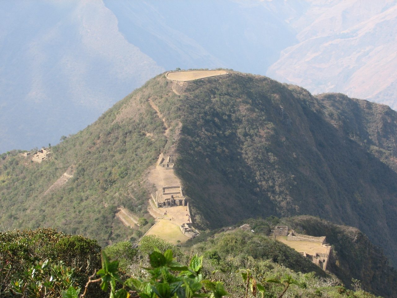
The Choquequirao trek is the hardest thing most people will ever do in Peru, and the difficulty is not where they expect it. It is not the altitude. It is a canyon. The standard four-day out-and-back drops you roughly 1,400–1,500 vertical metres from Capuliyoc to the Apurimac river, makes you climb the same amount back up the far side to reach the ruins, and then — because it is an out-and-back — makes you do both again in reverse. Four wall-of-the-canyon efforts in four days, the last of them a 1,400 m climb in full sun on an exposed slope with no shade and no water for long stretches.
That final climb is what breaks people. I have watched fit hikers who cruised the first three days sit down in the dirt above Playa Rosalina at ten in the morning with their heads between their knees. Nobody warns them, because the marketing line for this place is “Machu Picchu’s sister city, without the crowds,” and that sentence contains no information about what the walk is actually like.
So this guide leads with the honest version. Choquequirao is genuinely one of the best things I have done in Peru and I would go back. It is also a trek that a meaningful number of people should not attempt, and I would rather you worked out which group you are in now than at 1,500 m on day four.
The one number that decides everything
Forget distance for a moment. Distance is not what hurts here. The out-and-back is somewhere between 58 and 64 km depending on where you start, which sounds like a gentle four days until you look at the profile.
The reason competitors quote two different distances, by the way, and none of them explains it: 64 km is measured from the village of Cachora, and 58 km is measured from the Capuliyoc viewpoint about 10–13 km further along a rough road. Almost everybody now takes a vehicle to Capuliyoc. If a tour quotes you 64 km, they are counting road walking you will not do.
Here is the profile that matters, with the caveat that published altitudes for these waypoints disagree by up to 150 m and I have given ranges where sources genuinely conflict rather than pretending to a precision nobody has.
| Waypoint | Altitude | Change from previous |
|---|---|---|
| Cachora (village) | ~2,850 m | — |
| Capuliyoc viewpoint (trailhead) | ~2,900 m | road, usually driven |
| Chiquisca (campsite) | ~1,850 m (sources say 1,800–1,930) | −1,050 m |
| Playa Rosalina / Apurimac bridge | ~1,500 m (sources say 1,450–1,550) | −350 m |
| Santa Rosa Baja / Alta | ~1,900 m / ~1,950–2,100 m | +400 to +600 m |
| Marampata (hamlet) | ~2,900 m (sources say 2,850–3,000) | +800 to +1,000 m |
| Choquequirao main plaza | ~3,050 m | rolling, +150 m net |
Add it up and the four-day round trip is roughly 3,900–4,100 m of cumulative ascent and about the same descent. No competitor page I have found gives a cumulative figure for the standard route, which is odd, because it is the single most useful number for deciding whether you can do this. For comparison, the classic four-day Inca Trail to Machu Picchu has around 2,000–2,500 m of ascent spread over four days, and it is generally reckoned a hard trek.
The descents are worse than the climbs for a lot of people. Losing 1,400 m in a morning on loose, dusty switchbacks is a quadriceps and knee event, and the trail surface is churned by mule traffic into something between gravel and dust. If you have dodgy knees, this is the trek that will find them.
What Choquequirao actually is, and what it is not
Choquequirao sits on a ridge at about 3,050 m above the Apurimac canyon, roughly 50 km from Machu Picchu as a condor flies and an eight-day walk away on the ground. It was built in the fifteenth century, in the same imperial period as Machu Picchu, and it is associated with the Inca resistance that held out in the Vilcabamba region until 1572. It is big: the archaeological park covers something in the order of 1,800 hectares, and the built core is larger than Machu Picchu’s.
Here is the part that changes what the visit feels like. Only about a third of the site has been cleared and excavated. That figure — usually quoted as 30–40 per cent — traces back to Peruvian newspaper reporting from 2009 rather than to a published Ministry of Culture survey, so treat it as an informed estimate rather than a measurement. But the practical consequence is obvious the moment you arrive.
You are not walking through a manicured archaeological park. You are walking through partially cleared terraces with cloud forest growing back over the edges, along dirt paths that peter out, past retaining walls that emerge from vegetation and then disappear into it again. There are no barriers, no one-way circuits, no timed entry, no guard telling you to move along. On the day I was there I could see perhaps a dozen other people across the entire site, and for two hours in the afternoon I saw nobody at all. If you have been through the choreographed circuit system at Machu Picchu, where you follow a numbered route one-way and cannot double back, the contrast is the whole point of coming.
The trade-off is that you get much less handed to you. Signage is minimal. Many sectors are simply not interpretable without a guide or good reading beforehand. Some of what you see is reconstruction rather than original fabric, and it is not always labelled as such.
The llama terraces are the thing to see
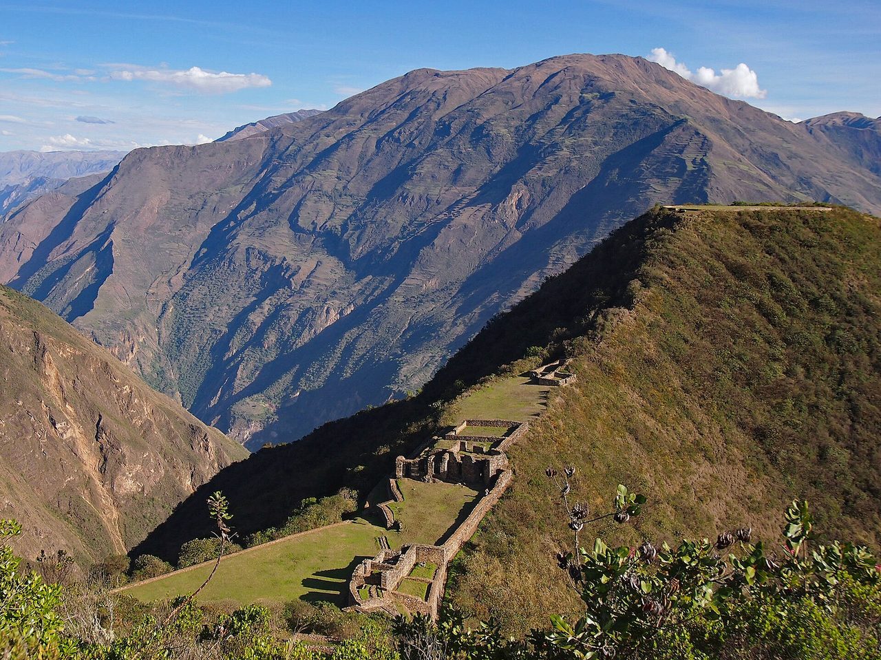
If you only make one detour at the site, make it this one. On a set of terraces below the main complex — the Paqchayoq sector, usually just called the llama terraces — white stones have been set into the dark retaining walls to form the outlines of camelids. There are around two dozen of them, walking in file across several terrace levels, with a smaller human figure at the bottom that is usually read as a herder. The largest figures span more than ten metres. They were only cleared and documented in 2002.
Nothing else at any Inca site looks like this. Zoomorphic figures built into architecture exist elsewhere, but not at this scale or concentration. It is the single most distinctive thing at Choquequirao and it is genuinely worth the effort.
And it is an effort. The llama terraces are several hundred vertical metres below the main plaza, reached by a long staircase down an extremely steep slope, and you have to climb every step of it back. Budget an hour and a half to two hours round trip and do not do it in the middle of the day. A lot of people who have walked for two days to get there look down that staircase, decide they are too tired, and go home having missed the best part of the site. Do not be that person: go down in the early morning when the terraces are still in shade.
A note on the UNESCO claim
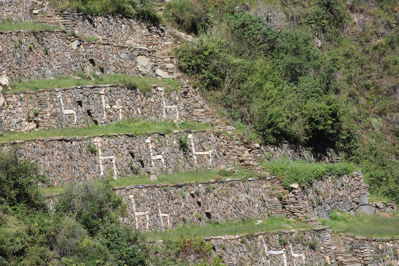
You will read that Choquequirao is a UNESCO World Heritage Site. It is not individually inscribed. What is inscribed, since 2014, is the Qhapaq Nan Andean road system, and one of Peru’s contributed segments is the Vitcos–Choquequirao road section. That is a real connection and worth knowing, but it is not the same as the site itself carrying World Heritage status, and pages that flatten the distinction are overselling. If you are collecting Peru’s World Heritage listings, Choquequirao is not a tick in that box.
How many people actually visit, with a year attached
Every guide to this trek repeats a version of “only 20–30 people a day visit Choquequirao, compared with thousands at Machu Picchu.” The comparison is real and the ratio is genuinely extraordinary. But the number is usually quoted as though it were a timeless fact, and it comes from reporting that is now several years old.
Here is what the recent figures actually say. Choquequirao’s record year was 2019, at 9,497 visitors — for the entire year. As of 2026 it is running at roughly 8,000–9,000 a year and has still not recovered its pre-pandemic peak, a point ProInversion itself makes in the documentation for the cable car project. The regional tourism authority in Cusco put it at “up to 9,000 annually” in April 2026.
Divide 8,500 by 365 and you get about 23 people a day. So the folk figure is roughly right as an annual average — but it is an average, and it hides the shape. In the wet season the number is close to zero and the site has repeatedly closed outright. In July and August you might share the ruins with fifty or sixty people. Meanwhile Machu Picchu runs a daily cap of 4,500, rising to 5,600 on peak dates. Choquequirao receives in a year what Machu Picchu receives in about two days.
One more piece of context that makes the trend clearer: the site was closed for over two months in early 2026, roughly February to late April, after heavy rain damaged the main mule track in from Cachora. It reopened in the week of 21 April 2026. The same thing happened in 2025. This is not a site with a rising visitor curve. It is a site whose access is fragile.
The cable car: what is actually true, as of August 2026
You will see the teleferico mentioned on nearly every page about Choquequirao, usually with a line like “get there before the cable car changes everything.” That framing has been running for more than a decade. Here is the sequence, because it is the clearest possible answer to “should I wait?”
- 2011–2013: regional governments announce a cable car from Kiunalla, in Apurimac, to Choquequirao. Original spec: about 400 passengers an hour, a 15-minute crossing, around S/125 million.
- January 2014: ProInversion publishes tender documents. An operator is to be announced that November.
- October 2014: the process is suspended. Cusco and Apurimac cannot agree how to split visitor revenue, since the line would start in one region and end in the other.
- 2015–2016: the project is stuck in the courts and then dormant.
- 2023: it is revived in a new form and granted viability approval.
- July 2024: the president announces in the Fiestas Patrias address that the tender will launch “this 2024.” It does not.
- March 2025: the tender is formally launched, with an award targeted for the fourth quarter of 2025. Stated private investment: US$261 million.
- Late 2025: that deadline passes with no award. ProInversion says it will be awarded “before July 2026.”
- April 2026: five parties have bought participation rights. Total project cost is now stated at around US$442 million as a co-financed partnership. Investors are publicly raising concerns about risk allocation and land acquisition.
- June 2026: ProInversion says the award is now expected between October and November 2026, with construction starting in 2027.
So: the contract has not been awarded, no ground has been broken, and nothing whatsoever has been built. Even on the most optimistic official schedule — award late 2026, construction from 2027 — operations would not begin until 2028 or 2029, and this project has missed every single target date it has ever been given, over twelve years, twice collapsing entirely.
My plain advice: do not plan a trip around it. Not next year, not in three years. If you want to see Choquequirao, the way to see Choquequirao is to walk there. Every page that implies the cable car is imminent is repeating a press release, and several of them have been repeating it since 2014.
Whether it would be good if built is a separate argument, and locals are split. The projected demand figure attached to the project is over a million visitors a year, which for a site that currently sees under nine thousand is not an upgrade but a transformation. The families running campsites at Chiquisca and Marampata, and the muleteers in Cachora, would not obviously benefit from a route that skips them entirely.
The Choquequirao trek day by day: the standard four-day route
This is the version almost everyone does. Cusco to Capuliyoc by road, down into the canyon, up the far side, one day at the ruins, and back the way you came. Distances vary a little by where your group camps.
Day 1: Cusco to Capuliyoc, then down to Chiquisca (~9–13 km walking, 4–6 hours)
You will be picked up in Cusco very early, often between 4 and 5 am, for a drive of roughly five to six hours. Walking usually starts at the Capuliyoc viewpoint in the late morning, which is unfortunate timing because the descent is west-facing and hot.
From Capuliyoc you can see Choquequirao’s ridge across the canyon, and you can see how far down you have to go first. The descent is relentless and monotonous: switchback after switchback on a dusty mule track, about 1,050 m down to Chiquisca. Nothing about it is technical. It is simply long, and it will hurt your knees more than you expect. Poles are not optional here.
Chiquisca is a set of terraced campsites with basic facilities and a couple of families selling cold drinks. It is warm at night — you are down at around 1,850 m in a canyon.
Day 2: Chiquisca to Marampata and on to Choquequirao (~11–14 km, 7–9 hours)
The hardest day. Groups leave between 4:30 and 5:30 am and the reason is not enthusiasm; it is that the climb out of the canyon becomes brutal once the sun is on it.
You drop another 350 m to Playa Rosalina and cross the Apurimac on a footbridge. Note that after a structural assessment, the authorities limited crossings to groups of no more than six people plus two pack animals at a time, so there can be a short queue when several groups converge. From the bridge the trail climbs continuously: about 400–600 m to Santa Rosa, where there is water and usually somebody selling drinks, then another 800–1,000 m of switchbacks to Marampata.
The Santa Rosa to Marampata section is short in distance — around 3 km — and gains something like 700–1,000 m. It is the steepest sustained climb on the route. There is very little shade.
Marampata, at around 2,900 m, is where most groups sleep, and it is a genuinely lovely place to arrive: a scatter of smallholdings on a shelf with the whole canyon laid out below and Choquequirao’s ridge in view. It is cold at night. In June and July it can drop close to freezing, which after a day in 30-degree canyon heat is a shock if you packed for one climate.
From Marampata it is about 3 km on a rolling contour path to the site entrance and the Choquequirao campsite. Some groups push on the same afternoon; others sleep at Marampata and walk it first thing.
Day 3: Choquequirao, then back down to the canyon (~15–19 km, 8–10 hours)
The morning is yours at the ruins. Realistically you want four to five hours to see the main plaza, the ushnu on the truncated hilltop, the upper sectors and the llama terraces. The site gate typically operates from about 7 am to 5 pm.
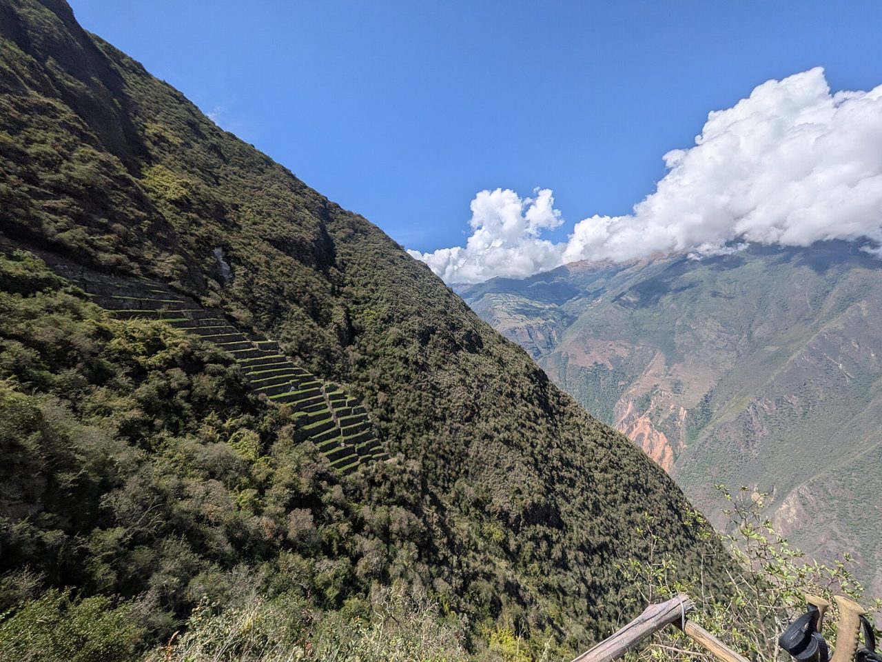
Then you turn round. The four-day version requires you to descend all the way from Marampata back to the river and climb up to Chiquisca or Santa Rosa the same day, which is a big afternoon on tired legs. This is the day where five-day itineraries earn their money.
Day 4: Chiquisca back up to Capuliyoc, then Cusco (~9 km, 4–6 hours)
The climb that breaks people. Around 1,050 m of ascent from Chiquisca to Capuliyoc on the same exposed switchbacks you came down on day one, with no shade after the first hour and no water source on the upper half. Groups leave at 4 am for a reason. If you are still climbing at 10 am you will be doing it in direct sun on a slope that radiates heat back at you.
Then a five-to-six-hour drive back to Cusco, arriving in the evening. If you have any flexibility, do not book a flight out of Cusco the same night.
Four days, five days, three days — which version?
| Version | Who it suits | Honest verdict |
|---|---|---|
| 3 days | Very fit, experienced, prepared for 9–11 hour days | Doable but grim. Three consecutive days of 1,400 m up and 1,400 m down. You will see the site tired and rushed. |
| 4 days (standard) | Fit hikers with multi-day experience | The right balance for most people who are genuinely fit. Day 3 is long. |
| 5 days | Anyone unsure of their fitness, or over about 55, or wanting to actually enjoy it | The version I would book. Splits the return, gives you a full unhurried day at the ruins, costs maybe US$80–120 more. |
| 8–9 days to Machu Picchu | Serious trekkers with high-altitude experience | One of the great treks in South America. Not a first multi-day trek. |
If you are choosing between this and Peru’s other long walks, it is worth reading a proper comparison of the country’s major multi-day trekking routes before you commit. Choquequirao is the hardest of them by a clear margin — harder again than the five-day Salkantay route over its 4,630 m pass, and a different proposition entirely from the Lares valley routes through Quechua weaving communities — and it is the only one where you do not finish at Machu Picchu, which matters more to some people than they admit in advance.
The 8–9 day traverse to Machu Picchu
The full route walks from Cachora to Choquequirao, then keeps going north over two high passes to join the Santa Teresa valley and finish at Machu Picchu. It is around 100–110 km and takes eight or nine days.
After the ruins you cross the Abra Choquequirao at roughly 3,300 m, drop all the way to the Rio Blanco at around 1,900 m, and climb to Maizal at about 3,000 m. Then it goes up: over the San Juan pass and old Victoria mines at roughly 4,130–4,200 m, down to the village of Yanama, and over the Yanama pass, which at somewhere between 4,600 and 4,670 m depending on which operator you ask is the high point of the whole route and one of the highest walkable passes on any commercial Peruvian trek. For scale, Dead Woman’s Pass on the classic Inca Trail is 4,215 m. Yanama is around 400 m higher.
The last days descend through Totora and Colpapampa into cloud forest and coffee country at Lucmabamba, over the ridge past the Llactapata ruins — which give you a distant view of Machu Picchu across the valley, and are one of the more rewarding of the lesser-known Inca sites scattered around Cusco — and down to Hidroelectrica for the walk or train into Aguas Calientes.
Who is this for? People who have done multi-day treks at altitude before, are comfortable with six to eight hours of walking on consecutive days for over a week, and want the whole ecological transect from high puna to cloud forest. Who is it not for? Anyone doing it because it sounds impressive. The traverse compounds every difficulty of the out-and-back and then adds 4,600 m passes. It also needs a separate Machu Picchu entry ticket booked in advance for a specific circuit and time slot — it is not covered by anything on the trek, and unlike the classic route it does not need a nominative trail permit, which is one of its genuine advantages.
Mules, muleteers and why you almost certainly want one
This is the practicality most guides skip past. On the Inca Trail, porters are mandatory and included. Here, if you are going independently, arranging pack animals is on you, and the window to do it is narrow: you hire mules and their arriero in Cachora, before you start. There is no meaningful option once you are on the trail, and there is certainly no option at the bottom of the canyon at 6 am when you have realised your pack is too heavy.
The going rate is roughly S/30–40 per mule per day, and the muleteer is charged separately or as part of the same day rate depending on who you ask — budget on the order of US$10–15 a day all in, and expect to also pay for the days it takes the animals to walk home. Custom is that you feed the arriero or contribute to his food. Confirm what is included before you shake hands; this is an informal arrangement, not a booking system.
Is it worth it? For the four-day route, carrying a full camping load down and up 1,400 m four times is a different trek from carrying a daypack. If you are on a guided tour this is all handled and the animals are included; check whether your operator uses mules or horses and what the weight allowance per person is, because the allowances are often lower than people expect.
One thing worth saying plainly: riding a horse down into the canyon is a bad idea and most operators discourage it. The descent is steep, loose and long. Horses are for the uphills and for evacuating people who have run out of legs.
Sleeping, eating and water
There is no lodge on this route. That sentence does more work than anything else here. A few operators market “lodge” trips, and what they mean is a basic room in a family cabin at Chiquisca or Marampata — walls, a bed, a shared cold shower. That is the top of the accommodation market on this trail.
The realistic options:
- Camping. Terraced sites at Capuliyoc, Chiquisca, Playa Rosalina, Santa Rosa Baja and Alta, Marampata and at Choquequirao itself. Typically around S/5 per tent per night, paid to the family who owns the ground. Free at the Choquequirao campsite.
- Basic cabins. At Marampata particularly, a dozen or so families rent simple rooms, in the region of S/15–30. Book nothing in advance; there is no system.
- Food. Families at Chiquisca, Santa Rosa and Marampata cook simple meals to order — soup, rice, eggs, sometimes trout. Prices are higher than in Cusco because everything arrives by mule. Carrying all your own food is possible and is what most independent trekkers do.
Water is the thing to get right. There are streams and taps at the campsites but nothing potable straight from the source, and the sections that matter — the climb from Playa Rosalina to Santa Rosa, and the climb from Chiquisca to Capuliyoc — have long dry stretches. Carry three litres minimum for those, four if you are slow, and treat everything. A filter bottle or chlorine dioxide drops both work; boiling works if you are camping anyway. On the descent into canyon heat, people underestimate consumption by roughly half.
Showers, where they exist, are cold. Capuliyoc has a hot shower for about a sol, which is not much use at the start of a trek and is a small miracle at the end of one.
Getting to the trailhead from Cusco
Cachora is about 165 km from Cusco on the road towards Abancay, and the journey takes five to six hours door to trailhead however you do it.
The independent way. Take a long-distance bus from Cusco towards Abancay and ask the driver to drop you at the Ramal de Cachora, the turn-off. That is roughly four hours and around S/40. From the turn-off, a colectivo down to Cachora costs about S/5 and takes half an hour, or a taxi is around S/30. From Cachora, a taxi up the rough road to Capuliyoc is S/50–60 for the vehicle. Buses on this route are reasonable by Peruvian standards; if you are unsure how the long-distance system works, the general rules for bus travel between Peruvian cities apply here too.
The organised way. Every tour includes private transport from Cusco to Capuliyoc, typically four to five hours in a minivan, and the return. This is the sensible option if you are doing a guided trek anyway.
Coming back, colectivos leave Capuliyoc for Cachora in the mornings; getting from Cachora back to Cusco in an afternoon requires either luck or a pre-arranged taxi to the Ramal to catch a passing bus.
The entrance fee, and what you actually pay for
The entrance ticket is S/60 for foreign adults and S/30 for students with a valid university ID, at the time of writing. It is bought in person, in cash, in soles, at the control point at Capuliyoc as you set off. There is no online booking, no advance reservation, no quota and no timed entry. Bring the exact cash; there is no card machine and no ATM anywhere on the route.
Older guides quote S/55. That was the previous price. As with everything in Peruvian tourism, check before you go — but the direction of travel on fees is only ever upwards, so budget the higher figure.
It is worth registering how small that number is. Choquequirao costs S/60. Machu Picchu at its cheapest is S/163 for a foreign adult, and S/211 for a circuit that includes Huayna Picchu or Machu Picchu Mountain. You are paying a third of the price to walk around a site three times the size with nobody in it. The price you pay is in your legs.
What the whole thing costs
| Item | Independent | Guided group tour |
|---|---|---|
| Transport Cusco–Capuliyoc return | S/150–220 (US$40–60) | included |
| Entrance fee | S/60 | sometimes included, often not |
| Camping / cabins, 3–4 nights | S/20–120 | included |
| Food | S/100–200 if buying on the trail | included |
| Mule + muleteer | US$40–70 for the trip | included |
| Gear rental in Cusco (tent, bag, mat, pack) | US$50–80 | usually included |
| Total per person | US$120–250 | US$450–800 (4–5 days ex-Cusco) |
Booking from Cachora rather than Cusco cuts the guided price sharply — figure US$250–350 — because you are buying a local guide and mules without the Cusco agency margin or the transport. The catch is that you have to get yourself to Cachora and arrange it in person, which usually means an extra night there. The 8–9 day traverse to Machu Picchu runs from about US$800 at the budget end to well over US$2,000 for premium operators, and the spread mostly reflects group size, food quality and whether the Machu Picchu ticket and train are included.
These numbers sit at the expensive end of what a Peru trip typically costs per day, but per unit of experience the independent version is one of the best-value things in the country.
When to go, and why the wet season is not just inconvenient
Dry season only. Realistically May to September, with June to August the most reliable and September a good shoulder month with fewer people. This is narrower than the general advice for choosing when to travel in Peru, and the reason is specific to this canyon.
Most Peru guides tell you the wet season means “afternoon rain and muddy trails.” On the Choquequirao trail it means something worse. The route is a narrow track cut into the wall of a steep, deep canyon with a lot of loose material above it. Heavy rain produces landslides that take out whole sections, and it undercuts the trail from below. The Apurimac rises. The footbridge at Playa Rosalina — already restricted to six people at a time — is the single point of failure for the entire route.
This is not theoretical. The site was closed for over two months in early 2026 after rain destroyed sections of the access track, reopening only in late April. It closed for the same reason in 2025. The authorities in Cusco were openly discussing closing it indefinitely in January 2026. If you plan a trek here in February and the trail is shut, you have no alternative and no refund.
The other reason to avoid the wet months is that cloud fills the canyon. The views — which are most of what you are walking for — are simply not there. If your dates are fixed in the southern Peruvian wet months, do something else and come back. Plan around the Andean dry season and this trek is superb.
One weather detail people get wrong: the canyon and the ridge are different climates. Dry-season days at the bottom of the canyon regularly reach the low thirties Celsius with no shade. Nights at Marampata in June and July can drop close to freezing. You are packing for both.
Who should NOT do this trek
I am going to be direct, because the alternative is people finding out at 1,500 m.
- Anyone whose longest hike is a day hike. Four consecutive days of 5–9 hours with 1,000 m-plus of vertical each way is not something you can improvise. If you have not done consecutive long days with a pack, do a different trek first.
- People with knee or hip problems. The descents are 1,400 m at a time on loose ground. This trek is a knee-destroyer and no amount of willpower changes that.
- Anyone on a tight schedule. If you have to be somewhere the day after you finish, do not book this. Injuries, exhaustion, altitude and weather all cause delays and there is no fast exit from the middle of a canyon.
- Families with young children. I have seen teenagers manage it well. Under about twelve, no.
- Anyone who mainly wants to see Machu Picchu. The out-and-back does not go to Machu Picchu. If Machu Picchu is the goal, there are much easier ways to get there and you should take one of them.
- People who need comfort. Cold water, pit toilets, tents, dust, and no way to charge anything reliably for four days.
- Anyone travelling in the wet season. Covered above. It is a safety issue, not a comfort issue.
Who should
Now the fair side, because I do not want the honesty to read as discouragement. This is a genuinely great trek and the right person will rate it above anything else they do in Peru.
Go if you have real multi-day hiking experience and want a route where the effort is proportionate to the reward. Go if the choreography at Machu Picchu — the numbered circuits, the timed entry, the one-way flow, the 4,500 people — is exactly what you are trying to escape, and the idea of a site of that scale with a dozen people on it appeals more than the famous view. Go if you like walking through a landscape that changes completely as you move through it, from dry cactus scrub at the bottom of the canyon to cloud forest on the ridge. Go if the historical thread interests you: this is where the Inca resistance regrouped, and standing in a plaza that half the forest has not given back yet does something that a well-swept archaeological park cannot.
And go if you want the version of Peru that most itineraries never touch. Choquequirao is the strongest single argument for travelling beyond the standard Cusco circuit, and it is one of the very few places where a trip that skips Machu Picchu entirely makes complete sense.
Preparation that actually matters
Altitude is the least of your problems here — the trek tops out around 3,050 m on the out-and-back, which is lower than Cusco. But you will have been living at 3,400 m for a few days beforehand, and you should still acclimatise properly in Cusco before starting. Two to three days minimum. Use them: a sensible number of days in Cusco is three or four anyway, and easy walking days around the Sacred Valley are far better preparation than sitting in a cafe.
Training matters more than acclimatisation for this one. The specific thing to train is descending: long downhills with weight, which is what actually wrecks people. If you can do a 1,000 m descent and walk normally the next day, you are ready.
Kit that earns its place: trekking poles, both of them, non-negotiable. Proper boots with grip, already broken in. A sun hat with a brim and long sleeves, because the exposure is total. Three litres of water capacity plus a treatment method. A warm layer and a proper sleeping bag for Marampata nights. Electrolytes. Blister tape applied before you get blisters. Cash in small denominations for campsites, drinks and the entrance fee.
Leave behind: cotton anything, a drone (the site prohibits them without permission), and any expectation of phone signal, although a couple of families at Chiquisca and Marampata now sell wifi by the hour for a few soles.
Common questions
Is the Choquequirao trek harder than the Inca Trail?
Yes, clearly, and it is not close. The Inca Trail has more total altitude — Dead Woman’s Pass at 4,215 m is well above anything on the standard Choquequirao route — but Choquequirao has close to double the cumulative ascent and descent, no porters carrying your kit unless you arrange them, more heat, less shade and worse trail surfaces. The Inca Trail is also fully supported by law, with a fixed permit system and licensed operators. Choquequirao is not.
Can I do it without a guide?
Yes. The trail is a single obvious mule track and navigation is not a real issue in the dry season. Plenty of people do it independently and it cuts the cost by two thirds. What you lose is interpretation at the site, which is significant given how little signage there is, and the safety margin of having someone with you if you get into trouble in the canyon. If you go alone, tell someone your itinerary and expected return.
How fit do I need to be?
Concretely: you should be comfortable walking 6–8 hours with 1,000–1,400 m of ascent, on consecutive days, in heat. If that sentence sounds fine, book it. If it sounds like a stretch, book the five-day version. If it sounds impossible, book something else — there are plenty of demanding but shorter adventure options around Cusco.
Do I need a permit?
No. Unlike the classic Inca Trail, where 500 permits a day including staff are nominative, sold months ahead and only bookable through licensed operators, Choquequirao has no permit system at all. You turn up at Capuliyoc, pay S/60, and walk. This is the single biggest practical advantage of the route and the reason it works as a last-minute plan when Inca Trail permits are gone — though the two-day route from Km 104 draws on a separate permit pool and is often still available too.
Is there anywhere to buy food and water on the trail?
Yes, at Chiquisca, Santa Rosa and Marampata, and in a limited way at Playa Rosalina. Expect basic meals, bottled water, and prices two to three times Cusco levels. Do not rely on any single one of them being open, particularly early or late in the season.
How many days do I need in total from Cusco?
Four days trekking plus two days acclimatising in Cusco beforehand is the minimum, so six. Five days trekking plus three in Cusco is better. If you are fitting it into a wider trip, it slots neatly into a longer Peru route as the adventure block, but do not put it at the start — you want to arrive already acclimatised.
Can you combine Choquequirao with Machu Picchu?
Yes, two ways. Walk the 8–9 day traverse, or do the four-day out-and-back, return to Cusco, rest a day and visit Machu Picchu separately by train. The second option is far more common and much more forgiving. Whatever you do, book your Machu Picchu ticket for a specific circuit and time slot in advance — the daily cap is 4,500, rising to 5,600 on peak dates, and popular slots sell out.
Is Choquequirao worth the effort?
If you want an archaeological site to yourself and you can handle four hard days, absolutely. If you want a photograph of the site with a llama in it, and you have never walked more than a day, no — and there is nothing wrong with saying so. Plenty of the best things in Peru require no suffering at all, and there is a long list of places worth building a trip around that do not involve descending 1,400 m into a canyon twice. This one does. Read the profile again, be honest with yourself, and then go, or don’t. Either answer is a good one. It is booking it without reading the profile that goes wrong.
A last practical note: whatever you decide, check the current status of the trail before you commit money. Access has been interrupted in each of the last two years. Local operators in Cusco will know within a day of a closure, and a few minutes of asking beforehand is worth more than any amount of general planning advice for Peru.