The History of Machu Picchu: Who Built It, Why, and How It Was Never Really Lost
The real history of Machu Picchu: Pachacuti's impossible royal estate, the engineering that holds it up, the quiet abandonment the Spanish never noticed, and the 1911 'discovery' that came with an asterisk.
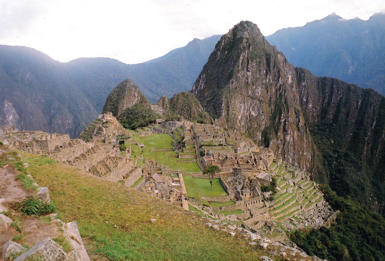
My favorite moment on any Machu Picchu visit isn’t the famous first view. It’s later, deep in the urban sector, when the guide puts a hand on five hundred years of granite and asks the group: “So — who built this?” Someone always says aliens, as a joke, mostly. And then the real story comes out, and it’s better than the joke. The history of Machu Picchu is short, strange, and still being rewritten — an empire that rose in a single lifetime, an emperor with a taste for impossible real estate, a city that worked for barely a hundred years and then sat quietly in the clouds while the world forgot to look up. It’s still being revised — radiocarbon dates moved the founding earlier just a few years ago, and scholars are now fairly sure we’ve all been calling it by the wrong name.
The short version: Machu Picchu was built around 1420–1450 as a royal estate for the Inca emperor Pachacuti, occupied by a rotating population of perhaps 750 people, and abandoned roughly a century later as the Spanish conquest shattered the Inca state — though the conquistadors never found it. Local farmers always knew it was there. In 1911 the American explorer Hiram Bingham, guided by those locals, carried the news to the world — and carried thousands of artifacts to Yale, which took a century to give back.
This is the story behind the stones you’ll walk on — part of our main Machu Picchu guide, and the context that turns a circuit ticket from a walking route into a narrative.
The whole story in one table
| Date | What happened |
|---|---|
| ~1420–1450 | Construction begins under Pachacuti; radiocarbon dating (2021) suggests occupation by the 1420s |
| 1450–1530s | Functions as a royal estate and ceremonial center; population ~500–750 |
| ~1530s | Abandoned amid epidemic, civil war and the Spanish conquest; the Spanish never find it |
| 1568 | Spanish land records name the gorge fields below the ridge as Pachacuti’s; the buildings are never described |
| 1572 | Túpac Amaru is executed in Cusco; the last independent Inca state ends |
| 1500s–1800s | Local farmers cultivate the terraces; the wider world forgets |
| 1874 | Herman Göhring’s map is the first to print both peak names — though it marks no ruins |
| 1902 | Cusqueño farmer Agustín Lizárraga reaches the ruins, leaves his name on a temple wall |
| July 24, 1911 | Hiram Bingham arrives, guided by Melchor Arteaga; global fame follows |
| 1912–1915 | Yale expeditions excavate; ~40,000 artifacts shipped to the US |
| 1948 | Bingham’s Lost City of the Incas becomes a bestseller; the road up is named after him |
| 1983 | UNESCO World Heritage listing |
| 2007 | Voted one of the New Seven Wonders of the World |
| 2011–2012 | Yale returns the artifacts to Cusco after a century of Peruvian pressure |
| 2021–2023 | Radiocarbon dating pushes occupation back to about 1420; genome work shows the staff came from across the empire |
| 2024–present | The circuit-and-cap system reshapes how the site is visited |
Pachacuti: the emperor who remade the Andes
You can’t explain Machu Picchu without explaining the man, and the man takes some explaining. In 1438, by traditional accounting, a royal prince named Cusi Yupanqui defended Cusco against an invasion his own father had fled from, took the throne, and renamed himself Pachacuti — roughly, “he who overturns the world.” He then spent three decades making the name literal: in a single reign, a regional Andean kingdom became Tawantinsuyu, the largest empire the Americas ever produced, stitched together with roads, terraces, storehouses and an administrative genius that still startles historians.
Inca emperors didn’t inherit their predecessors’ property — each needed new estates of his own. So the conqueror built like he conquered. Pachacuti’s portfolio ran up the Sacred Valley: Písac, Ollantaytambo, and — on a knife-edge ridge two days’ walk downriver, where the Andes tip into cloud forest — the estate we call Machu Picchu. Spanish colonial documents mention royal lands in this district belonging to Pachacuti’s lineage; no document describes the city itself. Everything else we know, the stones had to tell us.
Why build a city there?
Stand at the Guardian’s House and the question answers itself, but the specifics are wonderful. The ridge sits in a near-perfect loop of the Urubamba, which wraps the site on three sides a vertigo-inducing 400 meters below. Sacred peaks ring the horizon — Salkantay, Veronica — and the site’s own twin summits, Huayna Picchu and Machu Picchu Mountain, bracket the city like parentheses. For a civilization whose religion ran on mountains, rivers and sun, this wasn’t a building site; it was a temple that hadn’t been built yet.
The astronomy clinches it. The Torreón (Temple of the Sun) has a window that catches the June solstice sunrise dead-on; the Intihuatana stone’s angles track the sun’s seasonal stations; cave shrines below align with the December solstice. The best current synthesis: Machu Picchu was a royal estate in the way Versailles was a hunting lodge — technically true, wildly incomplete. It was a winter retreat, a diplomatic stage, a religious observatory and a statement in granite that Pachacuti’s power reached even here, where the mountains fall into the jungle.
The older romantic theories — a refuge of the “Virgins of the Sun,” a secret last city of resistance — dissolved under evidence: the skeletons Bingham’s team excavated turned out to be a normal mix of men and women, young and old, many showing origins from all over the empire. Machu Picchu’s population wasn’t hiding. It was staffing.
What it was for: four readings of the same ridge
Ask five Andeanists what this place was and you get four answers and a lot of hedging. That isn’t a failure of scholarship. It is what happens when a site leaves no writing of its own, and the only documents come from the people who ended the civilization that built it.
| Reading | Evidence for it | Weak point |
|---|---|---|
| Royal estate of Pachacuti | A 1568 land file: Inca nobles testify, parcel by parcel, that the gorge was Pachacuti’s | Lists valley-floor fields. Never describes the ridge |
| Sacred center | Reinhard’s mapping of the site against a cross of holy peaks and the encircling river | Explains the siting, not the housing or the tribute |
| Solar observatory | Dearborn and White on the Torreón’s June-solstice window and Intimachay’s December alignment | An alignment can mark rather than measure |
| Pilgrimage center | Magli’s reading of the site as the Inca origin story, built and walked | A minority position; most Andeanists have not moved |
| Agricultural frontier post | Kauffmann Doig’s case that the estate pushed coca and maize into the cloud forest | Wright calculated the terraces would feed about fifty adults |
The estate reading is the strongest, and it is worth knowing how strong. John Rowe also found a 1565 account by a Spanish envoy travelling to negotiate with the holdout Inca at Vilcabamba, who notes a place called Picho on the road. Bingham had read it. He quoted that account in print and left the Picho line out, because it would have wrecked his theory. A tax roll from the 1570s then assesses the “indios de Picchu” at 105 baskets of coca a year, delivered down at Ollantaytambo — a district with an address and a tax bill, and proof the state’s coca supply reached into the forested country on the Amazon side. What none of it proves is function, and Rowe was careful about the gap: it is quite probable, he wrote, that the high ground went with the fields. Note the hedge. Popular writing drops it.
The readings aren’t really rivals, either. Reinhard keeps the estate and adds the sacred landscape on top. Magli’s pilgrimage case leans on the site facing Lake Titicaca’s Island of the Sun, the empire’s creation ground. And the solstice work stands regardless: an emperor could own a house, hold a court and time the sun from one terrace, because Inca statecraft ran calendar and religion as one department — a fusion still on show at Cusco’s solstice festival.
How they built it (the part that breaks visitors’ brains)
No wheel. No iron. No mortar. No draft animals stronger than a llama. And yet: an estimated 60 percent of Machu Picchu’s construction is invisible — underground foundations and crushed-rock drainage layers that have kept a city perched on a rain-soaked ridge from sliding into the river for six centuries. The Incas were arguably better civil engineers than architects, and they were extraordinary architects.
- The stone was local — a granite quarry sits right inside the site (you’ll walk past it on the upper circuits), which is how the logistics pencil out.
- The famous joints — ashlar masonry so tight a knife blade fails — were achieved by patience: stone hammers, sand abrasion, and repeated test-fitting. The finest work went to temples; ordinary buildings got fieldstone and clay, originally plastered and painted.
- Everything is earthquake engineering. Walls lean inward a few degrees; doors and windows are trapezoids; corners interlock like Lego. In a quake, Inca walls dance and resettle. The Spanish colonial buildings of Cusco kept collapsing onto intact Inca foundations for centuries, a metaphor nobody needed spelled out.
- The terraces are machines: topsoil over sand over gravel over rubble — farmland, retaining wall and storm drain in one, which is why they still hold crisp lines after 600 unmaintained years.
When people reach for aliens, this is the part they’re gesturing at. The real answer — a state that could requisition thousands of rotational laborers (mit’a), feed them from imperial storehouses, and iterate stone-fitting for decades — is more impressive, not less.
The engineering nobody photographs
The masonry gets the attention; the water system is the better story. We know it in detail because an American civil engineer, Kenneth Wright, surveyed the site from 1994 with the Peruvian archaeologist Alfredo Valencia Zegarra and published it the way engineers do: with gradients.
It starts at a spring on the north flank of Machu Picchu Mountain, around 2,458 m, where a fault pushes water out of the granite. The Inca walled the spring and ran a cut-stone canal 749 m to the city at grades between roughly one and five percent — sized well above what the spring normally yields, which is what you build after watching a dry season.
Then the detail that reframes everything. Water arrives at a fixed elevation, so the first fountain has to sit where the canal gets there. Fountain one is at the emperor’s house. The plumbing was surveyed first and the royal residence was placed to meet it — the water decided the city plan, not the other way round.
Drainage is the other half. Wright documented around 130 outlets built into walls and terraces as they went up rather than cut in later. Excavation in the main plaza went down about 2.7 m, through topsoil and sandy fill onto a drainage layer of white granite chips — the waste from cutting the blocks, reused underneath. The site was white when it was new, incidentally.
Wright’s framing of the famous number is worth having precisely: he estimated that roughly half to sixty percent of the construction effort went below ground, into foundations, fill and drainage. Effort, not volume. Either way: two metres of rain a year on a fifty percent slope, unmaintained, for six centuries. They got things wrong too: terraces near the main drain still sit offset by a metre or so after a landslide during construction, never straightened out. If waterworks are your thing, Tipón is the showpiece and one of the better short trips out of Cusco.
A century of life in the clouds
At its height, Machu Picchu ran on a seasonal rhythm. When the emperor and his court came down from Cusco — probably in the highland winter, trading altitude for the estate’s gentler climate — the city might hold 700-plus people: royals and priests in the fine-masonry quarter, and a permanent staff of farmers, weavers, potters and llama drivers in the plainer buildings. Bone chemistry from the cemetery caves tells a remarkably cosmopolitan story: staff who grew up on coastal fish diets, highland tuber diets, jungle maize diets — the whole empire, in one small town’s teeth. Some 26 skeletons show a curious pattern of healed injuries consistent with… nothing violent at all; this was, by the standards of empires, a peaceful posting with good food and better views.
The city drank from a spring on Machu Picchu Mountain’s flank, channeled through 16 descending stone fountains — the first, purest one reserved for the emperor, naturally. Terraces grew maize and potatoes; the jungle below sent up coca and fruit; Cusco sent everything else. It worked, beautifully, for about a hundred years.
The bones that killed the Virgins of the Sun
Bingham’s expeditions sent human remains from the burial caves to Yale, where a staff osteologist, George Eaton, reported in 1916 that the great majority were female — on the order of four women to every man. Bingham had his answer. A settlement of almost only women had to be an Acllawasi, a house of the chosen women, and the Virgins of the Sun entered the world’s general knowledge, where they have been living rent-free ever since.
The problem is how you sex a skeleton. You read robustness — brow ridges, muscle attachments, the shape of the pelvis — against a reference population, and Eaton’s reference population was European and African. Andean people are smaller and less heavily built, so a perfectly ordinary Andean man read to him as a woman. He was also, it should be said, working for an expedition leader who had a theory.
The remains stayed at Yale, which is how the correction became possible. Around the turn of this century the physical anthropologist John Verano went back through the same collection with modern criteria and found the sexes roughly balanced; re-running Eaton’s own raw numbers gives a far milder skew than the one he published. The nunnery has been gone from the literature for roughly a quarter of a century. It is still all over the internet.
What replaced it is more interesting. Isotope work on the teeth, and since 2023 whole-genome sequencing, shows a population of permanent retainers — yanacona — resettled from all over: the coast, the far north of the country, the Ecuadorian highlands, and in a substantial number of cases the Amazon lowlands. People with no ancestral connection to one another were buried side by side, with their dogs. Around 174 individuals have been recovered from something like 104 caves, which is a lot of burials and still nothing like everyone who lived and died here across a century.
One clarification, because the correction gets over-applied: the chosen women were entirely real as an institution. Girls were selected, housed and trained by the state, and some were sacrificed at high mountain shrines; the frozen burials from summits above Arequipa are the hard evidence. What failed was never the claim that the acllas existed, but that this ridge was full of them.
The abandonment: quieter than the legend
No battle ended Machu Picchu. What ended it was logistics. In the late 1520s, smallpox — racing ahead of the Spanish themselves — killed the emperor Huayna Capac and set off a devastating succession war between his sons. By the time Pizarro’s men garroted the victor, Atahualpa, in 1533, the imperial economy that provisioned luxury estates was collapsing. A city of courtiers with no court, fed by storehouses no one was filling, simply wound down. The last residents likely walked out in the 1530s or 40s, taking anything portable and leaving the terraces to their neighbors.
Here’s the beautiful accident: the Spanish never came. Machu Picchu appears in no conquest chronicle, no extirpation record, no colonial tax roll under its own description — the invaders who melted Cusco’s golden gardens and built churches on its temples never learned this place existed. Its remoteness, so inconvenient for everyone since, turned out to be the greatest act of preservation in the Americas. The idols weren’t smashed here for one reason only: nobody with a hammer ever found them.
The four centuries the legend calls empty
“Lost for four hundred years” is the line that will not die. It is worth walking through what was actually happening in those four hundred years, because the answer is: quite a lot, most of it written down.
Start with the state. An Inca government kept going at Vilcabamba, deep in the forest north-west of here, from 1537 until the Spanish took it in 1572 and executed Túpac Amaru in Cusco’s main square that September — thirty-five years of independent Inca rule after this site had emptied. Getting out to Espíritu Pampa, where that government actually sat, is still a multi-day walk and one of the quieter of Peru’s long-distance trails.
Then the paperwork. The 1570s tax assessment on the Picchu district. Seventeenth-century Cusco land files, including a long-running case about people wanting to resettle a place written down as “Vayna Piccho.” Copies of the 1568 file made in the 1790s for a convent’s land claim. None of it describes the ruins. All of it shows a district with a name, an owner and a tax bill.
Then the nineteenth century. A German engineer, Herman Göhring, put both peak names on a printed map in 1874 — no ruins marked, and the two peaks the wrong way round, but the names are there. The following year the traveller Charles Wiener was told in Ollantaytambo about ruins at “Huaina-Picchu” and “Matcho-Picchu” and wrote it down, though he never made it up the ridge. Bingham had read Wiener. A German businessman, Augusto Berns, is sometimes said to have looted the site in 1867, though the researcher who first made that case has since backed away from it.
And then the people. Agustín Lizárraga climbed up in July 1902 with three companions — Enrique Palma, Gabino Sánchez and a labourer called Toribio Recharte — and wrote his name on the temple wall. Recharte came back and farmed the terraces. By 1911 two households, the Recharte and Álvarez families, were living on the site and growing crops on Pachacuti’s agricultural sector. The Peruvian scholar José Gabriel Cosío, up there in 1912, recorded flatly that people ascended frequently and that many had lived there, cultivating squash, yuca, sweet potato, cane and maize.
So why does the myth hold? Partly because it is a better story. Mostly because the man who told it wrote the bestseller, and he called it Lost City of the Incas. A place with tenants and a tax history does not sell in that font.
“Discovery,” with heavy quotation marks
Machu Picchu was never lost to the people who lived under it. Quechua farmers worked the lower terraces continuously; an 1874 map marks the name; and in 1902, Agustín Lizárraga, a farmer from Cusco, climbed up with three companions and did what humans do — wrote his name on the wall of the Temple of the Three Windows. Bingham saw that graffiti himself and noted it, honestly, in his journal.
Then came the famous day. July 24, 1911: Hiram Bingham III — Yale lecturer, future senator, part-inspiration (with others) for a certain fedora-wearing archaeologist — was hunting Vilcabamba, the actual lost last city of Inca resistance. A local innkeeper, Melchor Arteaga, mentioned ruins atop the ridge across the river and agreed, for a small fee and in the rain, to show him. A boy from one of the farming families led the final stretch. What Bingham found under the vines — and, on later expeditions, the chain of way-station ruins along what we now hike as the Inca Trail — rearranged his priorities permanently — though, in one of history’s better ironies, he went to his grave believing Machu Picchu was Vilcabamba. (It wasn’t. The real one, Espiritu Pampa, is deeper in the jungle and was correctly identified decades later.)
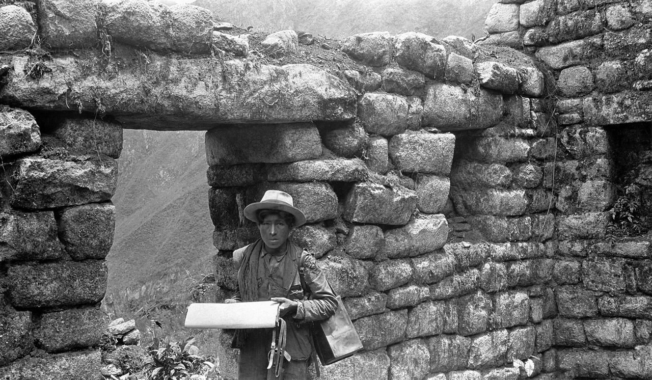
Bingham’s Yale-National Geographic expeditions cleared, mapped and photographed the site through 1915 — the haunting glass-plate images of vine-choked temples that made Machu Picchu a household name. They also shipped out some 40,000 artifacts — ceramics, bronzes, and the human remains from the cemetery caves — on an 18-month loan that Yale interpreted, creatively, as lasting until 2011. It took a century of Peruvian insistence, a lawsuit and a presidential campaign to bring the collection home; it now lives at the Casa Concha museum in Cusco, which is well worth an hour when you’re in town — see our Cusco guide.
The hundred-year argument with Yale
The artifacts deserve their own timeline, because the usual summary — Yale took things, Peru got them back — skips the part where everybody knew the terms from the start.
The 1912 decree that let the material leave was an explicit exception to Peruvian law, and reserved the government’s right to demand all of it back. The 1916 decree covering the later expedition went further: the material was Peruvian national property, and Yale and the National Geographic Society pledged to return it within eighteen months. Bingham himself wrote that November that the collection did not belong to them and had been released on condition of return. Peru asked formally in 1918 and again in 1920, got an extension to 1922, and received a partial shipment it called worthless.
Then very little for eighty years. Peru revived the claim in 2001; Yale toured the collection instead. Talks through the mid-2000s stalled on a criterion Yale introduced and Peru never agreed to: that only “museum quality” pieces need go home, which conveniently reclassified most of the collection as study material. Thousands marched in Cusco in 2006. In December 2008 Peru sued Yale in federal court in Washington; the case moved to Connecticut the following year. In November 2010, with a president leading a march in Lima and a Connecticut senator brokering, Yale settled.
The returns came in three waves: 366 museum-quality pieces and around a thousand fragments in March 2011, the bulk that December, and a final 127 crates flown into Cusco in November 2012. That also explains the confusing headline numbers — “forty thousand artifacts” and “four thousand artifacts” are both true, one counting individually catalogued fragments and the other whole objects.
The collection now sits at Casa Concha in a partnership between Yale and the local university, and the case is cited as the model for negotiated repatriation: not a court ruling, but a settlement trading title for access. It is also a good argument for giving Cusco an afternoon rather than a connection — a surprising amount of Inca stonework is still standing in the city, and our roundup of its essential sights has the shortlist.
The name is probably wrong (and that’s wonderful)
One more twist, fresh from the journals. “Machu Picchu” means “old peak” in Quechua — the name of the mountain at the site’s south end. Bingham asked locals what the ruins were called and recorded the answer somewhat loosely. In 2022, historian Donato Amado Gonzales and archaeologist Brian Bauer went back through Spanish colonial land records and Bingham’s own field notes and concluded the Incas almost certainly called the city Huayna Picchu — after the “young peak” it actually hugs — or simply Picchu. A century of global branding is unlikely to budge, but say it quietly at the Guardian’s House and enjoy knowing the wonder of the world is wearing its neighbor’s name tag.
Machu Picchu since 1911, at speed
The twentieth century turned a jungle ridge into an icon: the railway arrived mid-century, the Hiram Bingham Highway switchbacked up in 1948 (its namesake cut the ribbon), UNESCO listed the sanctuary in 1983, and a 2007 global vote stamped it one of the New Seven Wonders of the World — rocket fuel for visitor numbers that eventually forced the modern era of caps, timed entries and one-way circuits. It’s fashionable to grumble about the rules; the historian’s view is kinder. A site built for 750 residents was absorbing over 4,000 visitors a day, and the terraces Bingham photographed under vines are now managed like the irreplaceable archive they are. The circuits aren’t bureaucracy. They’re the price of the city getting to turn one thousand.
The 2007 vote was a poll, not a designation
Worth separating two things that half the tour listings weld together. The New Seven Wonders result came out of a campaign run by a private Swiss foundation, decided by internet and telephone voting, with a vote total announced by the organisers and never independently audited. UNESCO published statements in June and July 2007 saying there was no link whatsoever between its World Heritage programme and the campaign, and that it had declined to take part. “UNESCO New Seven Wonders” is not a thing. The 1983 inscription is the real credential; the 2007 poll was marketing.
What the sanctuary listing actually protects
The listing is not just the ruins. Machu Picchu is inscribed on both cultural and natural grounds, one of a small group of mixed sites worldwide, and the sanctuary covers a wide band of cloud forest — more than 400 bird species, spectacled bears, hundreds of tree species and a serious concentration of orchids. UNESCO’s own page gives two different figures for the protected area, which tells you how tidy the paperwork is. It also explains why the rules cover trails, drones and forest access rather than only the stones. Peru’s other entries are more varied than most visitors expect — see our guide to Peru’s World Heritage sites — and the sanctuary is one of the easier places to see Peruvian wildlife without a flight into the jungle.
Reading the history on your circuit
The best part: none of this is abstract once you’re inside. A quick key for matching story to stone as you walk (circuit permitting — routes are one-way, so check yours against the circuit guide):
- The quarry (upper circuits): half-worked boulders exactly where the masons left them one Tuesday in the 1530s — the whole abandonment story in a single frozen scene.
- The Temple of the Sun: the empire’s finest curved wall, with the June-solstice window — and beneath it, the cave shrine Bingham called the Royal Tomb. Note where the perfect ashlar meets rougher stone: that seam is Inca social hierarchy, rendered in masonry.
- The Temple of the Three Windows: where Lizárraga signed in 1902 (the graffiti was cleaned off long ago) and where the trapezoid windows frame the sunrise over the plaza.
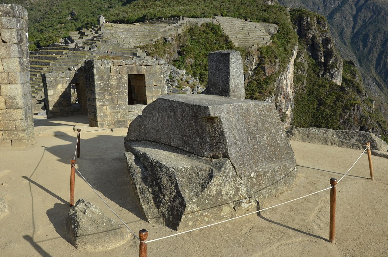
- The Intihuatana: the “hitching post of the sun,” one of very few ritual stones the Spanish never found and therefore never smashed — its siblings across the empire were systematically destroyed. You’re looking at a survivor.
- The fountains: sixteen of them, still running after six centuries, still in their original order of precedence. Fountain one belonged to an emperor. It works better than most hotel plumbing in the valley.
- The Temple of the Condor: a natural rock formation coaxed into a bird in flight — Inca theology’s habit of collaborating with stone rather than merely stacking it, in one glance.
How much time the history actually needs
Routes are one-way and rangers enforce them, so you cannot double back to re-read a wall you passed too quickly. Most circuits run two and a half to four hours and a guided group will use two of them — enough for the view, thin for the story. That is the real argument against the single-day dash from Cusco, and how many days to give Machu Picchu covers what a second entry buys. Good news on the legs: at 2,430 m the site sits nearly a kilometre below the city, so this is easier going than adjusting to Cusco’s altitude was.
What we still don’t know
Every other page on this subject ends confident. This one shouldn’t. The honest list of open questions is long, and it is the most interesting thing here.
- Whether the documents are about this site at all. “Picho” in the colonial files is a district. That the scribes meant the ridge-top town rather than a settlement on the valley floor is an inference, not a reading.
- Why it emptied. We have the context — epidemic, civil war, the collapse of the system that fed it. No document, no destruction layer, no departure date. “Defunded” is the best available explanation, not a finding.
- Whether any Spaniard ever stood here. The district was taxed, so the administration knew the name. Nobody wrote down the buildings, which is not the same as proving nobody came.
- What several buildings were for. The Temple of the Condor, the room with the paired carved basins, the cave at Intimachay: confident captions on the internet, cautious ones in the literature.
- Whether the alignments are instruments or symbols. The sightlines are real. Whether they were used to measure or to mark is still argued, including by the astronomers who published them.
Underneath all of it sits one hard limit. The Inca kept records on knotted cord, and the narrative khipu have never been read. The city has no voice of its own; everything above is inferred from stone, bone and paperwork written by the people who ended it. Worth holding on to when a guide tells you with total certainty what a room was for. Knowing the size of the gaps changes the visit more than any single fact does — and if you are still weighing the trip up, our verdict on whether the site lives up to its reputation takes the question seriously.
Myths, sorted
- “It was a city of chosen virgins.” Bingham-era misreading of skeletal remains; modern analysis found a balanced population. Retired.
- “It was the Incas’ secret last refuge.” That was Vilcabamba — the city Bingham was actually looking for. Machu Picchu was abandoned before the resistance, not because of it.
- “It was lost for 400 years.” Lost to Europeans and Limeños; known continuously to the Quechua farmers who paid rent on its terraces.
- “The stones can’t be explained.” They’re explained in exhaustive, admiring detail by two generations of archaeology — state labor, local granite, brilliant engineering, centuries of practice. The unexplained part is why that’s less viral than aliens.
- “Bingham discovered it alone, machete in hand.” He was led there by a paid local guide, past a farmer’s graffiti, to terraces that were actively being farmed. His genius was recognizing what he was looking at — and telling the world with unmatched flair.
History of Machu Picchu: FAQ
How old is Machu Picchu?
About 600 years. Radiocarbon dating published in 2021 shows occupation by around 1420 — a couple of decades earlier than the old textbook date of 1450 — with construction continuing for decades after.
Who built Machu Picchu, and how long did it take?
The Inca state under emperor Pachacuti, using rotational mit’a labor — likely a few thousand workers over several decades. It was still being extended when history pulled the plug.
Why was Machu Picchu abandoned?
Epidemic disease, civil war and the Spanish conquest collapsed the imperial system that funded and fed it. The city wasn’t destroyed or conquered — it was defunded.
Why didn’t the Spanish ever find it?
It sat two hard days off the main routes, screened by cloud forest, and by the conquest’s chaos nobody with power remembered it mattered. No gold rumors, no road, no reason — the best security system ever built by accident.
What does “Machu Picchu” mean?
“Old peak” — the mountain’s name, not (per 2022 scholarship) the city’s, which was probably called Huayna Picchu or just Picchu in its own time.
Where are the artifacts Bingham took?
Back in Peru since 2011–2012, at the Casa Concha (Museo Machu Picchu) in Cusco — the best single collection of the site’s material culture, ten minutes’ walk from the Plaza de Armas.
Can you visit the museum collections?
Yes, two of them: Casa Concha in Cusco holds the returned Yale collection, and the Manuel Chávez Ballón site museum near the bridge in Aguas Calientes displays later excavation finds. Both are quiet, cheap and excellent — ideal for the afternoon before your visit, when the history is about to become geography.
Is Machu Picchu older than the Incas?
No — despite internet insistence, excavation finds classic 15th-century Inca construction on bedrock. The nearby region has far older cultures, but this city is Pachacuti’s, start to finish.
Is Machu Picchu a UNESCO site or a wonder of the world?
Both, and they are unrelated. UNESCO inscribed it in 1983 after an expert assessment. The New Seven Wonders title came from a private foundation’s public poll in 2007 that UNESCO declined to join. Only one of the two carries any protection.
How much of what you see is original?
The stonework is overwhelmingly Inca, but it has been tidied. Clearing and restoration from 1912 onwards re-erected collapsed walls and rebuilt terrace faces, and the thatched roofs on a few buildings are modern. Nothing is a replica; plenty has been stood back up.
What came before the Incas in Peru?
Thousands of years. Caral on the coast is older than the pyramids at Giza, and the Moche, Nazca, Wari and Tiwanaku all rose and fell before Cusco mattered. The Inca empire at full size lasted under a century. The desert coast south of Lima is where that deep prehistory is easiest to see.
Final thoughts
What gets me about this history is its compression. A man renames himself World-Overturner and builds an impossible city; a century later it’s empty; four centuries after that a farmer signs a temple wall like a guestbook, and a Yale man with a camera makes it immortal. When you finally walk the circuits — and you should go armed with this story, it’s the best free upgrade there is — run a hand along the cold granite (where allowed) and consider: every “mystery of Machu Picchu” headline is really just the echo of an empire that did extraordinary things in ordinary daylight, and then had the good luck to be forgotten by exactly the right people. Plan your own arrival with the getting there guide, pick your dates with the timing guide — and go say hello to Pachacuti’s winter house.
Sources
- Wikipedia — Machu Picchu (with citations to Burger, Salazar et al.)
- National Geographic — Hiram Bingham and Machu Picchu
- UNESCO — Historic Sanctuary of Machu Picchu
- Machupicchu.gob.pe — official site history
- Burger et al. — New AMS dates for Machu Picchu, Antiquity (2021)
- Salazar, Burger et al. — Machu Picchu genomes, Science Advances (2023)
- Wright et al. — water supply and drainage at Machu Picchu
- John H. Rowe — Machu Picchu in 16th-century documents, Histórica (1990)
- ArThemis — the Machu Picchu collection: Peru and Yale
- UNESCO — statement on the New 7 Wonders campaign (2007)
Photo credits
All images are used under their stated licenses; thank you to the photographers.
- Photo: Peter van der Sluijs / CC BY-SA 3.0 via Wikimedia Commons — source
- Photo: Pavel Špindler / CC BY 3.0 via Wikimedia Commons — source
- Photo: Hiram Bingham III (public domain) via Wikimedia Commons — source
About this guide: Written by the Peru Tourism Guide team — writers and trip-planners who have explored Peru’s Andes, coast and Amazon over many visits and put hundreds of travelers on the right train to Machu Picchu. We update this guide as research evolves.
Last updated: August 2026.